This is topic Hurricane Frances in forum Film-Yak at Film-Tech Forum ARCHIVE.
To visit this topic, use this URL:
https://ft-forum.com/ft/cgi-bin/ubb/ultimatebb.cgi?ubb=get_topic;f=8;t=003530
Posted by Dennis Benjamin (Member # 1137) on 09-01-2004, 07:40 AM:
This one looks like another nightmare. By the time it makes landfall in Florida (?) it could get up to a category 5 (like Andrew in 1992). There is that stretch of warm water between the Bahamas and Florida that could make this the most deadliest storm to hit the US so far this century. Good luck to all on the east coast of Florida. Especially my extended family members at the two Crown Theatre locations in Miami and Jupiter.
Posted by Darryl Spicer (Member # 711) on 09-01-2004, 09:21 AM:
This one actually has the potential to slam the eastern coast of Florida and ride the east coast all the way up through virginia. All do to the rotation of the high preasure system over the Atlantic ocean.
Posted by Thomas Procyk (Member # 1170) on 09-01-2004, 11:54 AM:
People aren't taking anymore chances here. Orlandonians (?) are boarding up and stocking up already. It is the largest hurricane in diameter this century.
All we can do is pray.
=TMP=
Posted by Jeremy Fuentes (Member # 2135) on 09-01-2004, 11:59 AM:
We'll pray for you, buddy.
Posted by John Pytlak (Member # 331) on 09-01-2004, 12:28 PM:
Right now, it seems to looking like landfall late Saturday will be near Cape Canaveral (Kennedy Space Center). ![[Eek!]](eek.gif)
Good luck to all in its path.
Posted by Ron Yost (Member # 1850) on 09-01-2004, 04:49 PM:
From the AP:
"With Hurricane Approaching, Florida Calls for Evacuations
By THE ASSOCIATED PRESS
Published: September 1, 2004
Filed at 5:15 p.m. ET
MIAMI (AP) -- Nearly a half-million people were ordered to evacuate as Hurricane Frances swirled toward Florida on Wednesday just weeks after Charley's devastating visit, threatening to deliver the most powerful one-two punch to hit a state in at least a century.
Those planning to ride out the storm snapped up canned food, water and generators, while military helicopters and planes were flown out of the area and Cape Canaveral's Kennedy Space Center said it would close on Thursday.
Forecasters said the still-strengthening Category 4 storm could hit on Labor Day weekend as early as Friday night, less than three weeks after Charley raked Florida's western coast with 145 mph wind, causing billions of dollars in damage and killing 27 people.
"I can't emphasize enough how powerful this is. If there's something out there that's going to weaken it, we haven't seen it," National Hurricane Center director Max Mayfield said.
Gov. Jeb Bush declared a state of emergency, activating the National Guard.
Many homes in southwest Florida still have blue tarps patching holes in their roofs after Charley, and some streets remain full of storm debris that could become wind-blown projectiles.
"We've just gone through 2 1/2 weeks of torture trying to get our lives back to some sense of order," said Punta Gorda retiree Tom Hamilton.
Evacuation orders were posted for 300,000 residents in coastal areas of Palm Beach County, and 192,500 were told to leave mobile homes and low-lying areas of Brevard and Martin counties. The evacuation orders were set to take effect Thursday afternoon.
Frances was about 700 miles southeast of Florida on Wednesday afternoon, heading northwest on a course that would take it to the central portion of Florida's eastern coast. Residents of Georgia, North Carolina and South Carolina watched the forecast closely in case Frances took a sharper turn to the north.
Bush cautioned that "all the science in the world and all the technology in the world isn't going to be able to pinpoint exactly where the storm goes."
Frances would be the fourth storm to affect Charleston, S.C., this summer. Bonnie and Charley arrived within days of each other in August, and Gaston dumped more than 13 inches of rain in some areas when it came ashore Sunday.
With the ground saturated from previous storms, more rain and the slightest wind could cut utility service for thousands, even if they don't take a direct hit from the storm.
"With the ground this wet, trees could easily topple," said Tom Williams, a spokesman for Duke Power in Charlotte, N.C.
The storm and the mass evacuations are sure to spoil Labor Day outings and make a mess of holiday travel across the Southeast. Florida may reverse lanes on some highways to handle the evacuation traffic, state Emergency Management Director Craig Fugate said.
If Frances hits, it could be the most potent two-hurricane combination to hit a single state in at least a century of record-keeping. Frances is as strong as Charley, but forecasters said it could become a Category 5 with winds of 156 mph or higher.
Hurricane-force winds extended about 80 miles from Frances' center, making it about twice the width of Charley and increasing the possibility for damage.
The last time two major hurricanes hit Florida in rapid succession was 1950. Hurricane Easy struck Tampa around Sept. 4 of that year and Hurricane King hit Miami six weeks later on Oct. 17. They were Category 3 storms.
Nancy Cuffaro of Port Charlotte, whose home and pizza restaurant were damaged by Charley, said she is hoping Frances spares an area that is still suffering.
"I know we can't withstand too much. I really don't know what to think here. I'm lost. It's starting to get to me," she said.
A Home Depot to the south in Florida City, hit hard by Hurricane Andrew 12 years ago, more than doubled its daily sales and ran out of generators and plywood. It sold $50,000 worth of lumber Tuesday, said assistant manager Lisa Ftiffler.
North Miami Beach resident Lorraine Lewis bought a small cooking stove in case of emergency but wasn't planning to stick around long enough to use it.
"I have water and plastic and a plane ticket," she said.
State officials worried about finding enough room in shelters. Many hotel rooms in southern Florida are occupied by emergency workers and people left homeless by Charley. Some schools and community centers are still being used as shelters.
Deanna Creamer, who rode out Charley in her house in Punta Gorda, was still repairing roof and water damage. "I heard a little bit on the radio this morning, and I shut it off," said Creamer, 40. "I just can't imagine having to go through this again."
Charley destroyed or heavily damaged more than 30,000 homes and caused an estimated $7.4 billion in insured damage. It was the worst natural disaster to hit Florida since Andrew caused $15.5 billion in insured damage and killed 15 people."
--Ron Yost .. ![[Frown]](frown.gif)
Posted by Bobby Henderson (Member # 840) on 09-01-2004, 07:36 PM:
With Hurricane Frances ready to bulldoze through the Bahamas, I'll bet Manny Knowles is happy he moved to California!
Posted by Dean Kollet (Member # 1789) on 09-01-2004, 09:49 PM:
my parents live 5 miles from the Ocean in Melbourne, FL. They called to see if they could "crash" here for a weekend. Thomas is right, all we can do is pray...
Posted by William Hooper (Member # 71) on 09-02-2004, 12:52 AM:
quote: John Pytlak
Right now, it seems to looking like landfall late Saturday will be near Cape Canaveral (Kennedy Space Center).
Good luck to all in its path.
You ppl are like to drive me crazy!
Try "Landfall probablilties are now centered around Cape Canaveral." That is more accurate, & also indicates that there is an unspecified range around the center.
"Good luck to all in its path" -- NOBODY "in its path" is going to have good luck. Anything which is in the same place as the hurricane is blowed up. Plus, NOBODY knows what its "path" is unitl it has passed.
I don't know how these ideas of the forecast tracks being sort of bike paths for the hurricane have gotten entrenched. It was evidenced when the folks in Florida evacuated 100 miles & were SHOCKED, SHOCKED when they were still hit by the hurricane.
Go to the NOAA's National Hurricane Center
http://www.nhc.noaa.gov
There's a list of active tropical storms.
Under Frances, for our new graphics-fascistic world, click on "Maps & Charts". It will take you to a page with graphical representations of strike probabilities.
There's a link to a graphic of the predictions for the 5-day track
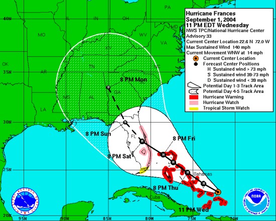
The line is not a streetcar line that the hurricane will be riding on. It is the MEAN of the probabilities extending from the storms present position. The white field surrounding the line which is the mean is NOT a picture of how far the rain will go out. It is the RANGE of probabilities, & you can tell that by the fact that it fans out from the storm's present position.
So the range of landfall probabilities includes all the west coast of Florida, & part of Georgia. This is why the hurricane watch area IS the entire west coast of Florida. Only slight deflection from the mean will generate a new range of strike probabilities.
Only John Hawkinson is allowed to talk about where the hurricane will go until this concept is understood!
The state of Florida is Not A Good Place To Be when the hurricane is coming, because evacuation essentially must be to get out of Florida - as can be seen from the range of strike probabilities & duration of destructive weather.
Thomas needs to head for the gulf, get on a boat & go to New Orleans, which is pretty much outside the range. The New Orleans tourist influx du weekend is Southern Decadence, which is a sort of convention of gay drunks in the French Quarter as opposed to the convention of football drunks in the French Quarter when there's some bowl game at Superdome. The drawback is as usuual the hotels are filled, but Thomas may be able to negotiate even more financially favorable terms for someplace to sleep with the Southern Decadence crowd.
The pictures are supposed to make it easy for everybody! But instead of interpreting them, people are Rorshaching all over them!
http://www.nhc.noaa.gov/text/refresh/MIASPFAT1+shtml/020226.shtml
This is what used to go BANG BANG BANG out of the teletype, & people seemed to get the idea. Even that table's precision is "CHANCES OF CENTER OF THE HURRICANE PASSING WITHIN 65 NAUTICAL MILES OF LISTED LOCATIONS THROUGH 8PM AST SAT SEP 4 2004"
65 Nautical miles!
The storm expected to make landfall between Friday 8PM & Saturday 8PM. So at THIS time, the probabilites within 65 Nautical miles for that time period are, out of 100:
FT PIERCE FL 5
COCOA BEACH FL 6
DAYTONA BEACH FL 10
JACKSONVILLE FL 14
SAVANNAH GA 12
Look at that spread! So I guess it means Fort Pierce is the place to be! Ummm, maybe not.
But look! Only a 14% chance of it being within 65 NM of Jacksonville, anyway! Why should they sweat it? I mean c'mon, only 14% !
Posted by Jack Ondracek (Member # 1466) on 09-02-2004, 01:35 AM:
A couple of good friends of mine have a home in Kissimmee. They were lucky not to have major damage to their house. They lost their pool cage (which was pretty common in that area), but that was about it.
This time, one of my friends is packing up his kids and heading to their drive-in in Indiana. Much to his consternation, the other is staying in Florida to ride it out.
Posted by Mark Lensenmayer (Member # 134) on 09-02-2004, 12:56 PM:
My source for accurate weather information is Weather Underground
The site is free, but with ads. Removing the ads costs only $5 per year, a fee I gladly pay. I'm on that site many times a day during bad weather. It has the most accurate weather radar, and the new charts even show the size and intensity of storms.
I agree that the science of hurricane prediction is very difficult. I just checked 5 of the leading computer models, and there is no consensus at all, although there is general agreement that the storm will hit somewhere in mid-Florida. Two show the storm moving up through Georgia, one has the storm moving across Florida, back into the Gulf, then up into the panhandle and then Georgia. The last takes the storm across Florida, back into the Gulf, THEN up into New Orleans!! We'll just have to wait and see. I've seen a number of 100% chances of winter storms go away at the last minute.
In any event, this one is going to be very nasty, and anyone anywhere close to it should pack up and get out.
Posted by Richard Fowler (Member # 893) on 09-02-2004, 03:29 PM:
We are having fun since it appears Miami will get tropical storm winds by tommorrow from the east. Our office is closed this afternoon since we are in a zone for evacuation ( two blocks away from Biscayne Bay ) and we have spent most of the day making final deliveries and making structures tight. My brother, who lives in Orlando, say they are more spooked due to the previous hurricane of a few weeks ago and the fact that this storm is three times larger.
Posted by Kyle Watkins (Member # 986) on 09-02-2004, 06:36 PM:
Driving by the home depot and dam they were pack, most stores stayed opend to midnight. Most store are out of plywood. Peole waiting in line for hours just to wait there turn. hopefully peopel learn there lesson and get stuff befor the hurican seasons even start. I say for my self was not ready, did last min shopping, some people even starting fighting over water. dont suprize me though. the super market i went to was very empty, 8 gas station, have no gas.
All i can say any one in the hurican area, get stuff way early, i say get most stuff at the beginng of hurican season. today seen a lot of people turned away.
Posted by Richard Hamilton (Member # 321) on 09-02-2004, 06:41 PM:
I just recently heard about the storm ( I am overseas and don't watch the local news), and tried to add insurance to some stuff that I have in storage in St. Augustine. Both the storage facility and my auto insurance are locked and can't add any additional coverage right now. Hopefully the storage unit can stand up to the winds, I think it is on a high enough elevation to keep it from flooding. I have full coverage on 1 car in storage (because of the bank loan), but I have an older corvette that I removed the full coverage because I knew I would be gone for awhile and not driving it. It's possible that in a few days, I'll have a vette listed for parts only on Ebay!
Oh yeah, in case my wife comes to this site: "I am also very concerned about all of the sentimental STUFF that is in storage too"
Posted by Dustin Mitchell (Member # 372) on 09-02-2004, 09:18 PM:
Well my stepdad who is an electrical lineman is heading down to Florida tommorrow along with the rest of the people from the company he works for. Since they're driving the trucks down there they can only drive 10 hours a day so they'll probably make it there by Sunday, probably after most of the damage is done. They think they might be there for a month or more .
Funny they got the call that they were going down for Charely but they didn't end up going. Guess they really need the help this time due to Francis' size and the fact that a lot of crews are probably still working on Charley damage.
Good luck to all in the storm path, and don't worry, my dad's on his way ![[Cool]](cool.gif) .
.
Posted by Richard Greco (Member # 2032) on 09-02-2004, 11:46 PM:
We have a friend in Miami that if his 1st choice of Naples is getting hit, he's coming here. On the other hand, I expect the pizza delivery business to be busy tomorrow. My former theatre already took down their marquee. One local gas station is out of gas. I filled up earlier tonight @ 7-11 just to be safe. It sucks though that Polk County is gonna get hit with another storm in less than a month. I'm not too worried though.
Just gotta be prepared.
Posted by Dean Kollet (Member # 1789) on 09-03-2004, 12:34 AM:
to show you how crowded the highways are....
my parents live in Melbourne, FL (the center of the projected landfall estimationg as of now) and they drove up here with our dog to stay with me until the storm dies down. The drive takes 4.5 hours tops and it took them over 12 hours!!!
Posted by William Hooper (Member # 71) on 09-03-2004, 01:34 AM:
quote:
--------------------------------------------------------------------------------
My source for accurate weather information is Weather Underground
They are all getting their data from NWS & re-packaging, altering, or re-interpreting it, from websites to the companies that re-package for industrial wx services for offshore oil companies, etc., ESPECIALLY to the guy on your TV who points at the weather.
The drawback with this re-packaging, re-organizing, & re-interpreting is that some need to just alter the material slightly to establish "brand differentiation", even though the NWS material is always the most accurate. As it gets further down the line, you get to things like the Yahoo link to the storm's predicted path which is STILL just a new graphic based on the NWS graphic produced for the data at 5am 9/2/2004. The NWS has revised those probablities about 5 times since, but Yahoo seemed to think that it's a static, locked prediction when they stumbled across it yesterday.
Watch the folks on TV or check whatever website you like, most if they're moderately intent on being more informational will say something like "we'll have another update at about 5 a.m" or whatever. Yes, that's the time of the next update from the NWS, which always notes when the next advisory will be issued.
http://www.nhc.noaa.gov/text/refresh/MIATCPAT1+shtml/030245.shtml?
All you have to do is read the NWS info, note when the next advisory will be, then re-check at that time when the advisory comes across. The rest is just people on the weather channel standing outside in the rain looking like they don't have sense to go inside. Why are you out there?
For tornadoes, etc., it's the NWS storm center in KC, for tropical weather it's the hurricane center in Miami, etc. They network & use data not only from their own offices, but from independent centers. It's all diffused from NWS.
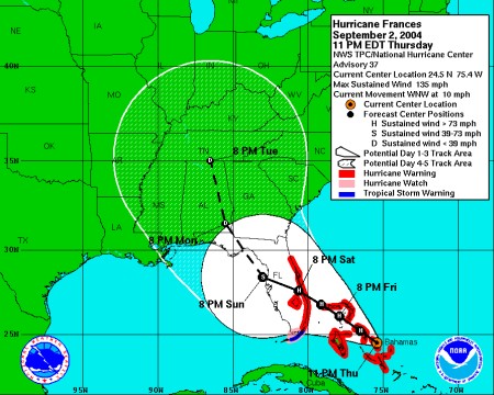
Yesterday at 5am, there was more confidence that it would still make landfall & then go northwards through the state, though it was already looking more likely to break west. Now it looks more likely to push further west & go across the state, then northwards in a phenomenon known locally as "There goes the Weekend." You still see the evacuation problems for FL. The problem with a hurricane going across the panhandle & folks moving "inland" is that they're going to be either sitting on the dirty side before it hits, or in it afterwards. It may still head north (remember that white area is still what's in the range of probabilities, & the line is only a mean), so the folks up that way won't be guaranteed safety. It's a crapshoot.
Also, when the TS gets back over the water, it can re-develop into a hurricane to cause more fun.
One of the worst things to deal with locally is always people being overwhelmed by fear or too lazy to think about complex problems, then refusing to think about the problems & saying "well, no matter where you are, if it's your time, you'll go", or "the weather is unpredictable, there's no point in getting too upset because there's nothing you can do", "I'm staying, if the Lord wants me to go there's nothing I can do", etc. Well, doofus, if you stand in front of a train, the Lord will decide it's time for you to go. People who decide to "ride it out" & survive always decide it indicates they're "chosen", & those that die have to have their friends & neighbors consoled for months with that sermon joke about the guy in the flood who keeps saying "The Lord will provide" until he dies & reaches St. Peter. Having to hear that thing over & over for months afterwards is some of the most horrible lingering damage after a hurricane.
[ 09-03-2004, 04:06 AM: Message edited by: William Hooper ]
Posted by Richard Fowler (Member # 893) on 09-03-2004, 07:19 AM:
Quiet this morning in Miami due to the storm being stalled in the Bahamas.....gives us a few more hours to tighten a few more screws. Our friend, Patty, who lives in West Palm Beach and is one of the regional directors of the South Florida Water Management Authority ( canals, dikes, flood gate control ), her main fear is the dike integrity on the North side of Lake Okeecobee. The dikes can handle up to 19 feet of storm surge....as long as they do not fail.
Posted by Jeremy Fuentes (Member # 2135) on 09-03-2004, 08:53 AM:
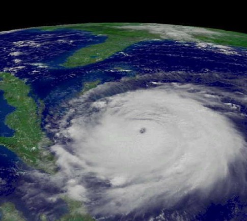
From Astronomy Picture of the Day.
Posted by Manny Knowles (Member # 1171) on 09-03-2004, 10:40 AM:
My mom phoned at about 8am (ET) to say that Frances was just hitting Nassau. They were originally expecting it at 2am but it slowed down...which is bad because the longer a hurricane stays over water, the stronger it can get.
At the time of the phone call, Nassau was experiencing sustained winds of about 80-85mph. By comparison, we were subjected to much stronger winds during Michelle and Floyd. The island does not appear to be in the path of Frances' eye -- centered about 40mi away at 8am today -- if that remains true, they would be spared from the strongest of the winds (120+ mph).
Predictably, Nassau is presently without electricity since about 10pm last night. At least part of the island is expected to lose telephone service.
Posted by Ken Lackner (Member # 1002) on 09-05-2004, 04:16 AM:
Okay. I'm scared. I've never been through anything like this. Every time I've prepared for a hurricane, it's never hit where I lived, at least nothing major happened. This is different. The entire state will be affected. And damn! It screws up my plans for California!
Richard G, you're lucky only one gas station was out. By 9am Thursday, 3 out of 5 stations that I saw in Boca were out. I waited about half an hour in line to fill up. How long did you have to wait?
Posted by Mark Gulbrandsen (Member # 72) on 09-05-2004, 09:58 AM:
"The dikes can handle up to 19 feet of storm surge....as long as they do not fail."
Well, if the dikes do fall at least the Everglades will be instantly restored to its before the Army Corpse of engineers chapter. The gators will appreciate that.
Mark
Posted by Tony Bandiera Jr (Member # 2365) on 09-06-2004, 01:38 AM:
Can't these poor folks in Florida catch a break? Just saw in tonight's news that yet another hurricane is predicted to land there, this time Hurricane Ivan. Enough already!! Nature can be a mother sometimes. ![[thumbsdown]](graemlins/thumbsdown.gif)
Here on the left coast UCLA's eggheads have predicted a magnititude 6.4 or higher quake for the Palm Springs area. It was supposed to have hit by today. Instead we've got record heat, which I'm sure the folks in Florida would rather have.
Take care folks, hope you all get through this safely!!
Posted by Richard Fowler (Member # 893) on 09-06-2004, 08:33 AM:
Yes, because of Ivan and the short holiday week we are leaving up some of the more "hernia to move" storm shutters if it appears on Saturday ![[uhoh]](graemlins/uhoh.gif)
Posted by Richard Greco (Member # 2032) on 09-06-2004, 09:40 AM:
Has anybody in the hurricane area had to go to work yesterday? My boss at Domino's opened yesterday. I worked from 5pm to 11pm. He was a crazy man to do this, but word spread that we were the only food place open besides Applebees and in the 7pm - 8pm hour, we made 62 pizzas. That is a shitload of pizzas.
This store averages 9,000 dollars in sales/week. The store made 3000 dollars yesterday alone.
Ken, as of today, I think there is one station in Plant City with gas. Gotta fill up today before I go to work.
Posted by Jon Miller (Member # 163) on 09-06-2004, 10:35 AM:
Speaking of gas stations...The TV news here showed footage of gas station canopies blown off or knocked over by the strong winds. I'm wondering -- did most gas stations survive or did a number of them suffer storm-related canopy damage?
Posted by William Hooper (Member # 71) on 09-07-2004, 01:04 AM:
Go to Florida, Ivan! They already tore up!
No need of making a mess EVERYWHERE.
Posted by Bruce McGee (Member # 131) on 09-09-2004, 06:32 AM:
Frances came up thru the east coast yesterday. Asheville only had about 5 inches of rain, but we had alot of flooding. My car got soaked, my basement in my home flooded, and our local water system sustained damage when two main feeder lines at the dam burst. This morning, no water. Glad I got a 1/2 bathtub full last night. Goodbye Frances! Dont come back!
Posted by Jason Black (Member # 684) on 09-09-2004, 01:43 PM:
William,
I hope your last post was in jest.
Bruce,
COunt your blessings! It could have been much worse. EVERYONE made out lightly with Francis... IVAN, OTOH is a dif'rent story. Looks like this bastage could do some real bad damage if he actually makes it to the southern coast... I'm hoping it takes a westward track and crosses the gulf. You Texas folks can handle a good storm every once in a while, right?
Posted by Jeremy Fuentes (Member # 2135) on 09-09-2004, 02:05 PM:
Jason, I would be happy if the storm hit here to give Florida a break. Bring it on Ivan... ![[fu]](graemlins/fu.gif)
Posted by John Pytlak (Member # 331) on 09-09-2004, 09:05 PM:
Close to 5 inches of rain from Frances in some parts of the Rochester area. No strong winds. Lots of flooded basements and roads, with several creeks overflowing their banks. Some lost electricity. A few schools closed for the day. The Genesee River was muddy and wild today, but fortunately, the Mount Morris Dam did its job in controlling the flow upstream. Clearing tonight, with really nice weekend weather ahead.
Posted by William Hooper (Member # 71) on 09-10-2004, 03:25 AM:
Only in that it was "recognition humor" for the folks in the gulf coast states. Come down to the gulf coast & you'll hear it adapted for other states in every state you visit. I've been in every gulf coast state except Texas when some hurricane has been approaching, & when the hurricane is mentioned at meetings, convenience store counters, gas station, ANYTHING, folks always say "Get away, (name of hurricane)! Go on over to Texas!" Or Louisiana, Mississippi, Alabama, or Florida, depending on where you are at the time. The humor is that 1) silliness because nobody can control where the hurricane goes, 2) very black gallows humor of passing around a gun like Russian Roulette with your friends.
The difference between approaching hurricanes for the gulf coast states & the Atlantic coast states is that for the Atlantic states, there is a chance the hurricane can just head north & avoid the coast. However, when a hurricane enters the Gulf of Mexico, it's just a matter of which location on the coast is going to get it. Somebody is doomed.
It's like Lifeboat!
Someone is going to die! Who will it be?
Although at the time, levity was a little more appropriate because Ivan wasn't a category four then.
When a gulf coast hurricane is coming, there's this sort of "Uh-oh, where's the WORST place for it to go, & what's left?" ordination of landfall horrors.
1. New Orleans: Nobody EVER wants another hurricane to go there. NOLA is below sea level, as almost everyone knows, & so a lot of water would be Really Bad, even with all the extreme flood control engineering. But what a lot of people don't know is that the Mississippi pretty much wraps around one side of New Orleans, & on the other side is Lake Ponchartrain. New Orleans will just fill up like a bowl. Betsy (the last hurricane to hit New Orleans) wasn't as bad as it could have been, things are more conducive to disaster now, & everybody just hopes luck will hold out. Evacuation when Georges approached scratched the surface of some of the problems of emptying New Orleans - it's not the richest city on the earth, & public transportation for lots of residents was a big problem along the routes away from the hurricane.
2. Florida: Everybody is terrified by the thought of a hurricane hitting New Orleans, but there's a belief that the people in Florida are Just Crazy. As Charley showed, there'd been no realistic operational consideration of evacuating the peninsula. They got a whole lot of schooling with Frances, though, & were lucky it came after the short subject of Charley. Nobody wants a hurricane to go to the Florida peninsula.
That leaves areas more easily evacuated inland: The Texas coast, Louisiana coast, Mississippi coast, Alabama coast, & the Florida panhandle.
3. The Louisiana coast: The Louisiana coast is undergoing massive erosion & subsidence - it's sinking, & losing an area the size of Manhattan every year. It's due to a number of things: the levees, channels being cut by offshore oil companies, etc. It's having major economic impact on the seafood & petroleum industries. The hurricane does not need to go hit the fragile, crumbling LA coast.
4. The Texas gulf coast: There's a lot of difference & a long way between Galveston & Brownsville, but the coastline is very complex with many inland bays & other features, & built up in many areas. Hurricanes striking the TX coast have one less-horrible aspect: hurricanes lose strength over land, & the "dirty side" is to the east. So when one hits the TX coast, the duration is usually shorter & less severe traveling inland. However, the coastal "profile" makes it a TERRIBLE place in many places. Also, there's this thing where a lot more people seem to die in Texas hurricanes.
5. The Mississippi coast: Love the MS folks, but MS has got those barrier islands which tend to knock the strength of hurricanes down when they come straight up the gulf. DIDN'T MAKE A WHOLE LOT OF DIFFERENCE WITH CAMILLE, THOUGH.
http://www.maritimemuseum.org/camille/index.htm
Picture of other hurricanes are always terrible pictures of destruction, but for those of us who stuck our heads out after Camille, there's still been no comparison. The eeriest thing, & it took a while to figure it out, was the frequent absence of debris. Everything just gone, like it was bulldozed AND hauled off.
Ivan could be as powerful as Camille, & possibly larger.
But Mississippi can evacuate inland, there's not much on the coast now (since Camille) except casinos as far as up to category 3 would be considered. Knock 'em down, nobody really cares. Category 3 and above, the back bay, etc. causes problems.
6. The Alabama coast: Well, uh, Mobile's right there. Frederic was bad, but all the other hurricanes (Georges, Danny, maybe missing a couple) were not above category 3 winds, & were mostly rain. Mobile knows roof & storm drains like Einstein
http://www.usouthal.edu/geography/fearn/480page/99Taylor/Taylor.htm
Most hurricanes, if they're just going to be mostly the rain which causes most of the damage with these things, can come on here & Mobile will just have several more rainy days, like when Danny moved into the bay & rained for DAYS. All the weather people are amazed by Danny, but the locals didn't see what the big deal was.
http://www.nhc.noaa.gov/1997danny.html
The Alabama gulf coast away from Mobile is pretty much, after Frederic, just a wall of condos now. Knock 'em all down, the people can get out & often have to.
http://www.southalabama.edu/meteorology/hurricanedanny.html
You can see what just the winds of Danny did to the condos. One of the MAJOR enablers of destruction during hurricanes is that the federal government CONTINUES to provide cheap insurance for hurricane & flood prone areas, stuff is knocked down again & again, the property owners act like it's their RIGHT to continually build in these areas & soak the taxpayers. The most recent 'development' of this is a huge overbuilding of condominiums on Dauphin Island, which is actually just a sand bar.
7. The Florida panhandle: They can evacuate inland, but they're still worse than the MS or AL coast. North Florida is actually more like South Georgia, & it's not very economically resilient. Florida makes a big deal over having no state income tax, but outside of areas where there's not a lot of tourism, you really notice the absence of managed drainage, streetlights, sidewalks, road maintenance, etc. There's a lot of destruction & sustained personal horror with hurricanes that make landfall on the Florida panhandle.
I said go to Florida, mainly at the time as the traditional joke, but if I had to pick, it would still be there.
1. The models have a slim chance it could break east, & the dirty side could be over the Atlantic.
2. The FL EMA's are all mobilized & working VERY well now, & preparation & recovery for #3 is going to be best handled by those folks.
3. The population is already non-complacent, mobile, & able to adapt to preparation & recovery.
4. A lot is already tore up & not repaired, as opposed to places that could get tore up newly.
5. This is very crass, but realistic: an election is coming up. MS, AL, LA & TX are already considered going to the incumbents, but FL is still a battleground state for its electoral vote. For preparation & recovery, the Federal gov't is going to be all over FL like an 18 year old virgin on a honeymoon.
More reasons why not to let the hurricane go to FL
1. If it skirts the gulf coast, the dirty side will grind up the FL coast all the way up, while the hurricane builds or retains its strength over the gulf.
2. The Tampa Theatre is on the Florida gulf coast. Shoo, hurricane, shoo!
2. If it goes over lake Okeechobee, there's going to be a cataclysm on the order of the last time a hurricane went over it.
When it gets into the gulf, someone's going to get it!
No denial or evasion, who do you pick?
The nhc's historical data site is down due to traffic load being distributed for current info, but it's fun to look at the tracks for all storms 1900 - present overlaid. Kinda chaotic on the east coast, a funnel in the gulf.
For Mark Lensenmayer, who likes looking at the individual models used for forecasts, relayed by the SFWMB for the 09/09/2004 5pm forecast:
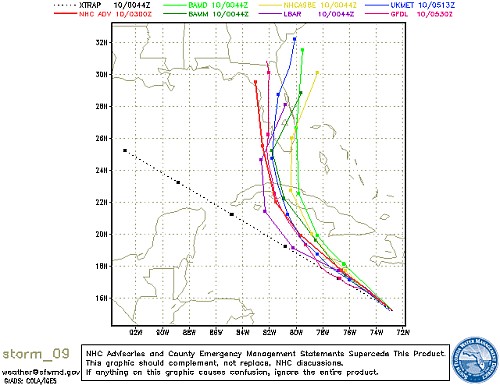
Note that it defers to nhc public product, because it's data the nhc uses for its public product. It's interesting, but not *extremely* useful, each track has its own margin of error, & the distribution is close enough to get a mean of the probabilities & indicat a range, which is what the nhc public product does. Faster, less susceptible to misinterpretation:
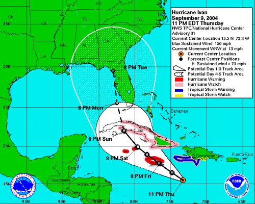
That's 11pm - oh no, expected a little more easterly now! The range of probabilites for the track has become wider over a longer period of forecast, too, indicating that it's expected to slow down. That's not good, either.
Edit:
Dayum, Jeremy, you don't want a category 4 hurricane going up your nose. The folks in Florida already got their stuff in the car & are ready to go, what's already been demolished can't be made worse, & all the emergency services (including just getting water & power restored) are fast-tracked.
It can't be that boring in Corpus Christi! Whatever happened to riding around & shooting at stop signs?
Posted by Bruce McGee (Member # 131) on 09-10-2004, 06:55 AM:
Most restaurants are closed here due to the ongoing water disruptions. There are water pick-up stations around town. Schools are closed again today. Many businesses will remain closed here today too.
We have been told by the water authority that 2 of the main spillways in the North Fork Lake, half of our water supply, are damaged due to flooding. They have been working 24 hours a day to repair this. They have to replace all the pipe foundations, and reset everything, then re-install the 2 huge pipes. We've never had anything like this happen in my lifetime, so this is a pretty big deal.
We saw the damage on TV yesterday morning on "Good Morning America." Biltmore Village got alot of damage from high water.
The French Broad river is still above flood stage, but is coming down fast. This is a rude wake-up call to all the people that own property here in flood plains. People being interviewed on TV are saying that they have never seen anything like this here. Well, I have, in 1962, and 1977. There's been alot of money spent on tourism in these flood-prone areas in the last 20 years. Much of that money is now gone with the current.
Thanks, Jason, for your comments.
Posted by Jeremy Fuentes (Member # 2135) on 09-10-2004, 07:14 AM:
quote: William Hooper
Jeremy, quote: William Hooper
you quote: William Hooper
don't want a category 4 hurricane going up your nose. The folks in Florida already got their stuff in the car & are ready to go, what's already been demolished can't be made worse, & all the emergency services (including just getting water & power restored)
are
fast-tracked."
I already got my stuff ready to go to. Any reason to have time off of work, I'm more than ready. But seriously, I think the people there have been through enough already. I'm more than sure they are ready to get back to see what they have left of their homes.
He also said: "It can't be that boring in Corpus Christi! Whatever happened to riding around & shooting at stop signs?"
That got old. Now I ride around and shoot paintballs at the box-office windows of the other theaters here. ![[evil]](graemlins/evil.gif)
Edit: I dont know why my post is coming up like that, but I cant seem to get it to quote right..
Posted by William T. Parr (Member # 677) on 09-10-2004, 02:44 PM:
Yeah Corpus does not have bad storms like the rest of the Gulf Coast. Last really bad hit Corpus took was 1980 Hurricane Allen, before that 1969 Ceila. Before the down plague Corpus was being hit once every 5 to 7 years so there long over due. I can honestly say though Florida definately does not need another storm up it's alley at the present time. We should really keep those folks in our prayers.
Posted by Mark DeLettera (Member # 125) on 09-10-2004, 07:54 PM:
Well.... we'll just have to wait and see. Retired from Kodak and living on the gulf coast of Florida for 5 months now and this is what we fell into!
Just got to ride it out and hope for the best. Made it through Charley and Francis... just hope Ivan will spare us too. Maybe not so lucky this time.
Glad it's a house that was built in the past year... making it a tad stronger than the older ones... (they keep stiffening the building codes).
WHO SAYS RETIREMENT IS MUCH LESS STRESSFUL?????? ![[bs]](graemlins/bs.gif)
Hope to be chatting on Tuesday! ![[beer]](graemlins/beer.gif)
Posted by William Hooper (Member # 71) on 09-13-2004, 05:04 AM:
quote:
Well.... we'll just have to wait and see. Retired from Kodak and living on the gulf coast of Florida for 5 months now and this is what we fell into!
"Florida, folks! Sunshine, sunshine! Perpetual sunshine all the year around! Let's get the auction started before we get a tornado."
-- Groucho Marx, selling Florida real estate in The Cocoanuts
They didn't show you this?
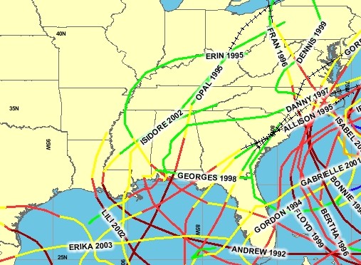
Hurricanes since 1990
Like William Parr mentioned, if a gulf hurricane doesn't hit the Florida peninsula, it might as well not exist for most of the media. Since the forecast track has moved westward, Yahoo news is posting an AP story that it looks like now Florida will be spared, & the Florida gulf coast may only be "brushed" by the hurricane. No mention that the hurricane is actually still going to make landfall somewhere; it's a hurricane headed straight for the Florida panhandle. Destin, Appalachicola, & Pensacola apparently aren't on their maps of Florida. The panhandle has had 4 hurricanes in the last 6 years.
Hurricanes 1965 to present: 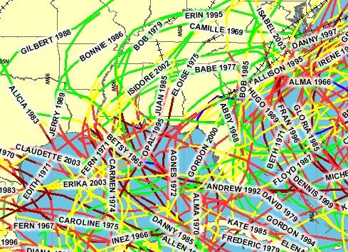
The maps show only hurricanes, but include the tracks as they downgrade to Tropical Storms as they pass inland. Tropical storms which come ashore are not shown.
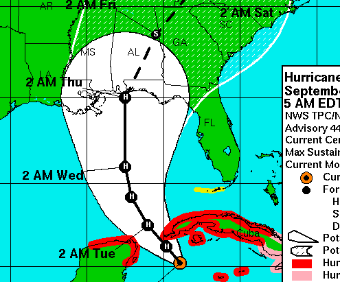
quote:
MUSN 216N 826W 33 X X X 33 PANAMA CITY FL X X 2 11 13
MUHA 230N 824W 4 3 1 1 9 PENSACOLA FL X X 2 12 14
MUAN 219N 850W 56 X X X 56 MOBILE AL X X 2 12 14
MMCZ 205N 869W 21 X X X 21 GULFPORT MS X X 3 11 14
MMMD 210N 897W 1 2 X 1 4 BURAS LA X X 7 9 16
MARATHON FL X X 1 3 4 NEW ORLEANS LA X X 4 10 14
MIAMI FL X X X 3 3 NEW IBERIA LA X X 2 10 12
Woo hoo! You can get even odds pretty much from Panama City to New Orleans this morning!
Go to Florida, Ivan!
Posted by Bruce McGee (Member # 131) on 09-13-2004, 07:10 AM:
One problem: If we get all the rain from Ivan that we got from Frances last week, we are in trouble. The ground here in NC is saturated and the rivers are still high. Our water system is still undrinkable, and tempers are flaring.
Bruce
Posted by Jason Black (Member # 684) on 09-13-2004, 11:19 AM:
Bruce,
Hate to hear of your woes. I'm wondering if I shoudl worry about anything since I'll be there during the 'expected' rains from Ivan? I'll be higher up of course, so the rains will have a more dramatic effect downstream, I'm sure...
Oh well, I plan to leave Wed. approx. 0900. Should be in Stecoah around 1600.
Posted by William Hooper (Member # 71) on 09-14-2004, 03:54 AM:
Hurricane warnings & evacuations begun on the coast from Grand Isle, Louisiana, to St. Marks, Florida.
Evacuations begun of sections of New Orleans.
Tomorrow, preparations will begin to bring online the powerful hurricane fans atop the Government Plaza building in Mobile, which are directed into the Gulf of Mexico to repel approaching hurricanes.
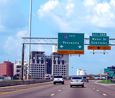
Things are growing short at local merchants: at Wal-Mart last night, the only shopping carts left were the ones with screwed up wheels that jerk or wobble.
Standard hurricane provisions are going fast: plywood, batteries, 100 foot roll sheets of plastic.

Posted by Bruce McGee (Member # 131) on 09-14-2004, 07:00 AM:
Thanks Jason. Asheville got the OK to drink its water again this morning. Good thing. I was about to have to wait in line for a couple of cases of bottled water again. I've learned one thing about bottled water:
I have a whole-house filter system on water coming into my house, except what goes to the toilets. I always thought it did a good job on water taste. Now that I have been drinking bottled water, I like it. I'll continue to buy it.
We had green-ish water for 2 days after Frances came thru...
Oh yeah, if you are going to the Blue Ridge Parkway, beware of at least 3-4 slides that have happened around this area between Asheville and Mount Mitchell. Have a blast on your visit!!
Posted by John Pytlak (Member # 331) on 09-14-2004, 07:20 AM:
quote: Bruce McGee
I have a whole-house filter system on water coming into my house, except what goes to the toilets. I always thought it did a good job on water taste. Now that I have been drinking bottled water, I like it. I'll continue to buy it.
When my daughter lived in Charlotte NC, she had several serious incidents of kidney stones. The doctors told her that that area of North Carolina was especially prone to kidney stones because of the very high calcium content of the drinking water. Might be another good reason to stay with bottled water.
Posted by Leo Enticknap (Member # 534) on 09-14-2004, 08:56 AM:
Or just boil and/or filter all the crap out of it. The water in York is as hard as nails, plus they put tons of flouride in it, with the result that it tastes vile. Shortly after I moved there I bought a combined water filter/kettle device: by filtering and boiling tap water, then keeping a jug in the fridge to drink cold, I reckon I've saved a fortune on the bottled water I would otherwise have had to buy (though, that having been said, the filter cartridges aren't cheap). I don't know if this process would get rid of calcium, though.
Posted by Bruce McGee (Member # 131) on 09-14-2004, 09:36 PM:
Asheville's water system is the largest gravity-fed system in the USA. The head-waters that fill North Fork Lake are surrounded by the Blue Ridge Parkway and old-growth forest land. It is a beautiful lake, and the water tastes great. BUT... It travels thru 100+ year old pipes to my home. The city has known for years that the system needed major work, but political foot-dragging prevails!
Ivan is moving toward us in the Gulf. Time for a new topic!!
Posted by Mike Olpin (Member # 1115) on 09-14-2004, 10:31 PM:
Here is an interesting story about how a direct hit from Ivan could cause New Orleans to sink.
quote:
The worst-case scenario for New Orleans - a direct strike by a full-strength Hurricane Ivan - could submerge much of this historic city treetop-deep in a stew of sewage, industrial chemicals and fire ants, and the inundation could last for weeks, experts say.
Posted by Leo Enticknap (Member # 534) on 09-15-2004, 01:51 PM:
Link to a BBC online Hurricane Ivan update at 1751 GMT (1151 EST) today...
quote:
At 1500 GMT, Ivan's centre was about 235 miles (290km) south of Mobile, Alabama, and moving northwards at 13mph (21km/h).
Good luck William...
Posted by William Hooper (Member # 71) on 09-15-2004, 11:19 PM:
Go to Florida, Ivan!
Posted by Leo Enticknap (Member # 534) on 09-16-2004, 02:10 PM:
Same URL as above, but the story has been updated at 1747 GMT today:
quote:
Hurricane Ivan made landfall near the port of Mobile, Alabama, at about 0300 (0700 GMT), bringing ferocious, swirling winds and heavy rains.
"We have never seen a hurricane of this size come into Alabama," said Governor Bob Riley. Most people had heeded the governor's advice and moved inland, while those remaining behind were crammed into emergency shelters.
It was the worst weather to hit the area in 25 years and left 100,000 people without power. The BBC's Matt Frei in Mobile says the destruction was not as bad as predicted, although he described seeing streets littered with felled trees, traffic lights ripped from their power lines and torn billboards.
Posted by Evans A Criswell (Member # 381) on 09-16-2004, 05:33 PM:
Here in Huntsville, AL, there's lots of rain and very gusty winds. This morning, we had light rain and a slight wind, but around lunch, the wind started picking up and the rain increased. Around 4:00, it started getting worse, but I don't think it warranted nearly everything in the city shutting down and closing up. It's really annoying. It's rain and wind, and we've had worse than this on occasions before and things didn't close.
Posted by William Hooper (Member # 71) on 09-17-2004, 09:44 AM:
the eye was very large, and the center of it came onshore in gulf shores alabama slightly to the east of mobile.
mobile is a big mess, but it's nothing compared to what's to the east of the mobile bay all the way into the flordia panhandle. pensacola's bridges were destroyed, the storm surge leveled everything from the beach inland for blocks from south baldwin county al to pensacola fl. ivan remained a hurricane halfway up the state even in montgomery. for some reason, folks in mississippi and alabama take hurricanes seriously and evacuate so there were very few fatalities, but there are at least 14 dead in florida and they haven't been able to get within miles of the beach yet in searches for bodies. more people have died so far in this hurrican than since floyd in 1999.
all the hurricanes are different, this one was another new one. it moved very slowly, had rain only in the front half, but the destruction from wind was immense due to spawning an unprecedented number of tornadoes. like one about every other block. there was no clear weather after this one, but about 12 more hours of gales.
usual sights of roads made impassable by all sorts of debris, the best 2 roads that identically had the lines & poles for the power line following it in the road - all the poles broken off exactly at the base, & a mile or more of of poles identically spaced (because of the attached lines) lying across the road like a railroad track laid there. roofs, cars, boats, etc. in trees. usually tornado sight of pine woods with all the trees snapped over at the same height about 14 foot above the ground, like a lawnmower went over.
power out everywhere of course, will be days, weeks or maybe months coming back on due to luck of the draw. phones out, cable out, some tv stations down, etc., cut off from commucincation. i still have this old propane-fired amiga, but as even propane is getting scarce, am conserving it by not turning on the monitor or using the shift key.
didn't hit new orleans, which would have been a bloodbath.
like most businesses, convenience stores and grocery stores are closed because of no power, cannot find m and m's and the emergency authorities say it could be days or weeks before complete m and m service is restored to the area.
Powered by Infopop Corporation
UBB.classicTM
6.3.1.2